
CALL US: Canmore Location (Rental) 403-879-7930; Calgary Location (Sales, Rental & Service) 403-879-7940
Nearby Bike Trails
Legacy Trail - the Most popular!!
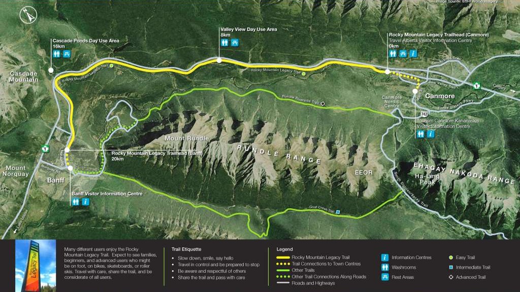
The Banff Legacy Trail is now more commonly referred to as the Rocky Mountain Legacy Trail since the extension from Canmore was established. Built to commemorate Parks Canada’s 125th anniversary, the first two legs of the trail were completed in the fall of 2010. It is a scenic three metre wide, 26 kilometre long, commuter trail connecting the small mountain town communities of Canmore and Banff. The route runs parallel to the highway and offers breathtaking views of the surrounding mountains. This is a great trail for families and cyclists of all abilities to enjoy.
The Rocky Mountain Legacy Trail survived the June 2013 floods and has since expanded! Minor damage was sustained near the west end of the trail as you near Banff Avenue, for which repairs are well underway. For now a safe ride-around option has been put in place, keeping users off the highway. The recent expansion to the trail means that cyclists can now safely park in Canmore and ride the trail out to Banff without having to get onto the highway (Trans-Canada Hwy 1) at any point. Begin your ride from Banff town centre or park at the Travel Alberta Visitor Centre (located on the south side of Hwy 1 on the west end of Canmore Service Road) and begin your ride from there. The Legacy Trail runs all the way to the Town of Banff with an option to continue on to Hwy 1A from Vermillion Lakes. This is a fantastic trail enjoyed by all, including cyclists, runners and rollerbladers.
Length – 22 km (26 km w/optional extension);
Elevation gain – 455 m;
Level – Easy;
Suggested Gears – Comfort Bike; Road Bike; E-bike
Tags – Dogs on leash; Nature trips; Road Biking; Walking; Bird watching; Running; Forest; Paved; Views; Wildflowers; Wildlife
Click here to download legacy trail map (2-pages, PDF).
Source from https://www.bikepirate.com/banff-legacy-trail/
Goat Creek Trail
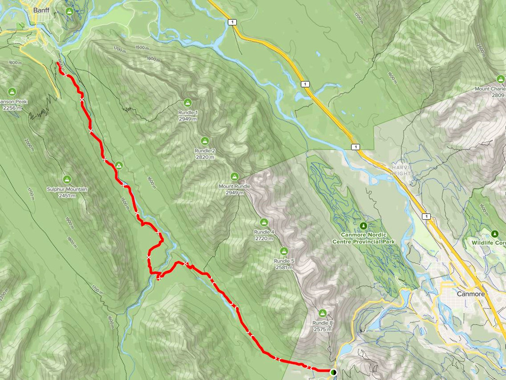
Goat Creek Trail is a 37.3 kilometer moderately trafficked out and back trail located near Banff, Alberta, Canada that features a river and is rated as difficult. The trail offers a number of activity options and is best used from June until October. Dogs are also able to use this trail but must be kept on leash.
This trail is primarily used by mountain bikers, but hikers are always welcome. The choice is yours whether you want to use this trail as an out and back, or start in Canmore and finish in Banff. The trail can be quite rough in some spots, so make sure you manage your speed.
Length – 37 km;
Elevation gain – 1,351 m;
Level – Hard;
Suggested Gears – Mountain Bike
Tags – Dogs on leash; Nature trips; Bird watching; Forest; River; Views; Wildlife; Bridge out
Source from https://www.alltrails.com/trail/canada/alberta/goat-creek-trail
TransCanada Trail
Trans Canada Trail: Canmore is a 6.1 kilometer lightly trafficked point-to-point trail located near Canmore, Alberta, Canada that features a river and is good for all skill levels. The trail offers a number of activity options and is best used from May until October.
Length – 6 km;
Elevation gain – 173 m;
Level – Easy;
Suggested Gears – Comfort Bike; Road Bike; E-bike
Tags – Kid Friendly; Hiking; Mountain Biking; Nature trips; Walking; Running; Forest; River; Views; Bridge out
Source from https://www.alltrails.com/trail/canada/alberta/trans-canada-trail-canmore
Hoodoos from Bow Falls Trail
Hoodoos from Bow Falls Trail is a 10.0 kilometer heavily trafficked loop trail located near Banff, Alberta, Canada that features a waterfall and is rated as moderate. The trail offers a number of activity options and is best used from June until September.
Length – 10 km;
Elevation gain – 305 m;
Level – Moderate;
Suggested Gears – Comfort Bike; Mountain Bike; E-bike
Tags – Dogs on leash; Hiking; Mountain Biking; Nature trips; Walking; Bird watching; Running; Partially Paved; River; Forest; River; Views; Waterfall; Wildflowers; Wildlife; Historic Site
More Information
More Biking Trails in Canmore Area:
#1 Upper Grassi Lakes Trail Loop (Length – 4.3 km; Elevation gain – 233 m; Level – Easy)
#2 Bow River Trail (Length – 6.1 km; Elevation gain – 137 m; Level – Easy)
#3 Spur Line Trail (Length – 7.4 km; Elevation gain – 215 m; Level – Moderate)
#4 Rundle Riverside Trail (Length – 17.7 km; Elevation gain – 755 m; Level – Hard)
Note: Canmore Nordic Centre – we do not suggest riders to this place! This place is designed for more advanced mountain bike trips with FULL SUSPENSION bikes. As of June, 2022, we did not receive any full suspension bikes in summer 2022 due to supplement shortage. Without proper gears, riders to this place take your own risks.
More Biking Trails in Canmore Area Published by town of Canmore:
(Bow Valley Trail East & West Trail maps available in PDF format, click Here to link to the webpage)
More Biking Trails in Banff Area:
#1 Bow Valley Parkway (1A) (Length – 17 km; Level – Moderate; Note: from 1A east entrance to Johnston Canyon)
#2 Boat Landing to Bow Falls Trail (Length – 6.1 km; Elevation gain – 153 m; Level – Moderate)
More Biking Trails Published by National Park Canada in Banff Area:
(Click Here to download map, 2-pages, PDF, source from National Park Canada)

Banff Red Chair Location Map
(For the “collectors” punching on social medias, Click Here to download map, 1-page, PDF, source from National Park Canada)
We have Bike Carriers for Rent!
Do you plan for a bike trip a bit far from our location? No problem, we have “Bike Carriers” for rent. We have multiple options available, no matter your vehicle equips with a hitch or not, our 2 or 3 or 4 bike carriers fit for most vehicles. Half price if you also rent a bike with us! Click Here to scroll down to the bottom of the reservation page or just give us a call for availability!
RUNDLE BIKE is proudly powered by WordPress